This section allows you to view all posts made by this member. Note that you can only see posts made in areas you currently have access to.
Topics - Kudi Nepal Di
Pages: 1 ... 13 14 15 16 17 [18] 19 20 21 22 23 ... 25
341
« on: June 28, 2010, 07:06:35 AM »
Rahon is a city and a municipal council in the Nawanshahr district of the Indian state of Punjab.
Geography
Rahon is located at 31°03′N 76°07′E / 31.05°N 76.12°E / 31.05; 76.12.
It has an average elevation of 250 metres (820 feet).Situated on the Jullundur City Jaijon Doaba line of the Northern Railway, Rahon is 7 KM from Nawashahr, the tahsil/subdivision headquarters, and 65 KM from Jalandhar, the district headquarters. It is also connected by road with Nawashahr (8 KM), Jadla (12 KM), Ludhiana (51 KM), and Phillaur (37 KM). Its population was 12,046 in 2001. It is a Class-III municipality.
History
It is said to have been founded about 2000 years ago by Raja Raghab, who called it Raghupur, by which name it continued to be called in correspondence by the Pandits of the place till early in the present century. After that it came into the possession of Gujars, who were driven out by the Mahton Rajputs, who in their turn succumbed to the Ghorewaha Rajputs, whose conquest of the country is put down as having occurred in the time of Muhammad Ghori (d. 1206 AD).
Their Ruler Raja Rajpal, renamed the town ‘Rahon’, after a certain lady called ‘Raho’. In support of this derivation may be quoted the opinion entertained by some that, it is unlucky to speak of this town by its proper name, in the morning, when fasting. Till breakfast it is called ‘Zanana shahr’, or ‘Women town”. In the time of Ibrahim Lodhi (1517-1526 AD), the town is reported to have a population of 145000 and was a flourishing trading center on the route to Tibet and Central Asian Countries. The art of shoe making attained a high degree of skill and a pair prepared by one Mian Khaki Shah of Rahon is said to be still lying in the museum at Lahore (Pakistan). Towards the beginning of the Mughal period, the town was occupied by the Ghorewaha Raja of Machhiwara, Rana Udho. He actively assisted Akbar (1556-1605 AD). During his fight for the Delhi throne and defeated and captured the rebellious Bairam Khan. As a reward, the Raja allowed to retain the jagir of Rahon. In Akbar’s time, Rahon was the capital of the Dardhak Mahal and gave its name to one of the two tarafs into which the Mahal was divided. In Aurangzeb’s reign (1658-1707 AD) a brick fort was built here. The Rajputs of Rahon were Chaudhris and men of much influence during the Muhammadan rule.After the Raja of Rahon converted to Islam, he was beheaded and territories seized by the Rana of Jadla who belonged to the same clan.
In 1710 AD, Rahon fort was conquered by Banda Bahadur, while on his way to Jalandhar, from Shams Khan, the local Mughal governor. Later, it fell back into the hands of Mughals. In 1759 AD, Rahon was seized by Dhallewali Confederacy Sikhs led by Tara Singh Gheba, and remained in their possession till Tara Singh's death, when it was added to Maharaja Ranjit Singh’s dominions but domination of Pandits continued in local administration. Pandit Sardars ran the administration for centuries. After the collapse of the Sikh Empire, the descendants of the Rana of Rahon came to prominence again and the Rana of Rahon, Chaudhry Abdul Rehman of Rahon was a member of the Legislative Assembly of Punjab from the Unionist Party before Indian Independence. Pandit Buta Ram Qasir Jagirdar continued to serve as Municipal Councilor and local leader of Rahon for next two and half decades after independence.
It is evidently a very old town and, from its commanding situation on an eminence overlooking the low valley of the Satluj, must have been a place of importance. Rahon’s importance was primarily due to its location on the ancient trade route to Tibet and Central Asia and it began to fall in importance as soon as a new route through Kabul was opened during the Mughal times. Its proximity to big marsh made it a victim of periodic out breaks of malaria in an epidemic form. Consequently, its population has greatly declined. It was said to be 69000 when the British took over the place after the First Anglo Sikh War in 1846 and it was 6607 in 1971. After the division of the country in 1947 the Muslim population of Rahon had to go to Pakistan and the Hindu and Sikh population that came from Pakistan started living here. It was also the hometown of Yash Chopra, Owner of yash raj films in his early years
Places of Interest
There are several places of historical interest in Rahon. There is the Panch Tirthian tank which was got excavated by Rana Udho as a place of pilgrimate for his five sons who could not proceed on pilgrimage due to the illness of his father. The samadh of Rana Udho also exists at Rahon. There is another tank, called Ramsar, adjoining the samadhs of Tara Singh Gheba and his brave widow which was constructed by their son Jhanda Singh. There is also an old serai, said to have been built in the reign of Shah Jahan (1627-1658 AD). Another holy place in the town is Suraj Kund which is said to have been
built by one Bawa Aughar during the period of Pathan rule. There is also a tomb, built during the rule of the Tughluq dynasty, which is said to contain the ashes of a saint.there is very famous piligrimate of baba ram ratan ji.it is 'chaten samadh'.
Demographics
In the 2001 Indian census, Rahon had a population of 12,046. Males constitute 52% of the population and females 48%. Rahon has an average literacy rate of 81%, higher than the national average of 65.38%: male literacy is 88%, and female literacy is 75%. In Rahon, 11% of the population is under 6 years of age.
Industry
Rahon is a booming industrial town with a large amount of textile, rice mills and other industries in the city, and its juridiction area (approx 102 Km²) including all nearby towns and villages. The most famous industry in Rahon is Rhythm Textiles, part of the Saluja group which produces thread for many clothing brands like Octave, Spykar and Koutons. A large amount of rice is processed in numerous rice mills in and around Rahon.
342
« on: June 28, 2010, 06:59:34 AM »
At one time a base of Patiala province was set up by Baba Ala Singh approximately around year 1719 who also laid the foundation of Patiala two hundred fifty two years ago. Baba Ala Singh conquered Sirhind fighting his battles from this place. When he overpowered remote areas then from administrative angle he shifted his capital from Barnala to Patiala.
In Punjab, at present, there are half a dozen villages having their names resembling Barnala town. District Mansa has a village named Khara Barnala. Near Nawan Shehar, there are places Barnala Kalan and Barnala Khurd. Amritsar district too has a village named Barnala.
The common prevalent details reveal that this place was a village named Anahadgarh. In neighbouring village Bhadalwadh Rungarh Muslims used to live who indulged in cattle-stealing and plundering acts in surrounding villages grazing cattle in their crops. Following tormentation by Rungarh Muslims, people of Anahadgarh went to Bhadaur for help. Baba Gama was known for his might. When people went to Bhadaur at that time, Baba Gama was not there in his house but his brother Baba Ala Singh came along with them and he forced all Rungarh Muslims to run and started living there planting a tree (it being a Dera at that time marking foundation of a village).
Eminent Sikh historian Giani has recorded the details of setting up of Barnala in the annals of Khalsa in this manner that in the year 1775 Baba Ala Singh after offering Bhadaur (set up by King Padhar Sain) to his brother Duna Singh came to Barnala region which was lying aloof at that time. Setting it up, he made it his capital and took under his control surrounding villages. It too appears that Anahadgarh may be existing before and must have been deserted following attacks of Dharvis.
There are different opinions about the nomenclature of Barnala. Some are of the view, Vaaran being a region because of frequent storms was at that time also called Varna. So Barnala was called a land of too many storms which later on became Barnala because of precision of example. Another view reveals that a fort here is said to be built by Baba Ala Singh in which there was a ‘Baahuli’ (a well which had stairs going down). That too due to precision and Malwai accent was known as ‘Baain’. Thus Baain Wala ultimately became Barnala. Thus these are different views only but no historical detail is available that how name Barnala came into existence.
The part pertaining to markets of present Barnala city is about eighty years old. The initial Barnala belongs to fort, its surrounding population, Sandhu and Bajwa Pattis. It was in fact a village. All rulers lived in the fort. The officers and other respectables lived outside the four-walls of the fort. The agriculturists inhabited Sandhu and Bajwa Pattis.
Barnala which at one time was the capital of province was District Headquarter when Patiala province came into existence and Bathinda and Mansa used to be its Tehsils (sub-divisions). At the time of independence of India, Bathinda became separate district. After India got freedom, in the year 1954 following abolition of provinces new state of Pepsu was made. Then too Barnala was a district headquarter and Rampura Phool and Malerkotla were its Tehsils (sub-divisions). When Pepsu State with Patiala as its capital was disbanded and merged in Punjab then status of Barnala district got degraded. Now it is only a sub-division. Earlier on, Barnala being a district headquarter had District and Sessions Judge Court but when Barnala became sub-division, it was offered Additional Distrcit and Sessions Judge Court vested with all the District and Session Judge Court powers.
The Dera Baba Gandha Singh of Barnala too appears to be linked with the history of Barnala. Once Bibi Pradhan kaur (famous with the name of ‘Pradhan’), daughter of Maharaja Ala Singh, reached Mukatsar journey then. She met Baba Langar Singh. Listening to sermon and seeing serving of meals without any break left deep impact over her mind. She requested Baba Langar Singh that a saint of high conduct like him be sent to Barnala who may start congregation and meal service like this there. Accepting her request, Baba Langar Singh deemed his learned disciple Pandit Nikka Singh worthy for Barnala. Maharaja Ala Singh had heard a lot very well about Baba Langar Singh and Pandit Nikka Singh and whenever he talked of appointing a talented teacher for Bibi, then name of Pandit Nikka Singh used to be mentioned in high esteem. Complying with orders of Baba Langar Singh, Pandit Nikka Singh reached Barnala then Maharaja Ala Singh provided him with a beautiful house for residence. Pandit ji started congregation here. In this way, Dera Baba Gandha Singh came into existence and in fort regular meal-services were arranged where hundreds of people took meals and even today hearths of Baba Ala Singh present and Gurudwara is famous with the name of Baba Chulle (Hearths).
Apart from this, Barnala remained a nerve-centre of special activities during Praja Mandal movement and S. Seva Singh Thikriwala was also a prominent Praja Mandal activist who was born in village Thikriwala just four kilometres away from Barnala. Every year on January 19, in his memory a three day fair-cum-festival is organised where political conferences are also hosted by various political parties.
343
« on: June 27, 2010, 12:48:19 PM »
Gurdaspur is a city in the state of Punjab, situated in the northwest part of the Republic of India. It is located in the center of and is the administrative head of Gurdaspur District. It was the location of a fort (later turned into a Brahmin monastery) which was famous for the siege it sustained in 1712 from the Mughals.
History
Gurdaspur was founded by Sahib Deep Chand and was named after his grandfather Guriya in the beginning of 17th century. In his honour, this city was named Gurdaspur. He bought land for Gurdaspur from the Jats of the Sangi Gotra. Guriya, a Sanwal Brahmin of the Kaushal Gotra came from Paniar, a village situated 5 miles north of Gurdaspur. The ancestors of Guriya had come from Ayodhya and settled in Paniar. Guriya Ji had two sons Nawal Rai and Pala. The descendants of Nawal Rai settled in Gurdaspur and Nawal Rai’s son Baba Deep Chand was a contemporary of Guru Gobind Singh. It is believed that Guru Gobind Singh gave the title of Ganj Bakhsh (Owner Of Treasure) to Baba Deep Chand. The descendants of Baba Deep Chand are called Mahants
Gurdaspur was the last bastion of Banda Bahadur. Banda Bahadur's legend lives on in the poem "Bandabir", by the Indian Nobel prize winner Rabindranath Tagore. The poem, written in the Bengali language, has been translated into English, since.
Geography
Gurdaspur is located at 32.03°N 75.52°E. It has an average elevation of 242 metres (793 ft). The district comprises an area of 1889 km². It is bounded on the north by the Jammu region, of Jammu & Kashmir. Chamba, on the east by Kangra district and the Beas River, on the south by Amritsar district, and on the west by Sialkot, and occupies the submontane portion of the Ban Doab, or tract between the Beas and the Ravi River. The district includes sanatorium of Dalhousie mountain which stands 7687 ft. above sea-level. This station, which has a large fluctuating population during the warmer months, crowns the most westerly shoulder of a snowy range, the Dhauladhar, between which and the plain two minor ranges intervene. Below the hills stretches an undulating plateau covered with abundant timber, made green by a copious rainfall, and watered by the streams of the Ban Doab, which, diverted by dams and embankments, now empty their waters into the Beas directly, in order that their channels may not interfere with the Ban Doab canal. The district contains several large Jheels or swampy lakes, and is famous for its snipe-shooting. Pathankot is another town from which one has to pass to enter Jammu and Kashmir and Himachal Pradesh state.
Demographics
According to the 2001 India census, Gurdaspur had a population of 67,455. Males constitute 53% of the population and females 47%. Gurdaspur has an average literacy rate of 78%, higher than the national average of 59.5%: male literacy is 80%, and female literacy is 75%. In Gurdaspur, 10% of the population is under 6 years of age. Sikhs make up about 65% of the population in Gurdaspur the rest are Hindus and Christian. before partition Gurdaspur had majority of Muslim residents(50.6%), mostly Ahmadiyyas and was going to be handed to Pakistan, but was given to India, because if the ruler of the kingdom of Kashmir decided to integrate with the Indian Union, it would be accessible contiguously to India.
Pakistan and the Gurdaspur district
The Gurdaspur district in the undivided Punjab had on the basis of the 1941 census an overall Muslim majority of 51%, which came about in the first decades of the 20th century, mainly due to the out-migration of 45,000 Sikhs to the Chenab colony between 1891 and 1901. Gurdaspur had four tehsils (sub-districts) viz., Shakargarh (51.3% Muslims), Batala (53% Muslims), Pathankot (65% non-Muslim) and Gurdaspur it self (50.5% Muslims). Gurdaspur straddled a major river of the undivided Punjab of India, the Ravi, with Shakargarh Tehsil on the West Bank of the river and the rest of three Tehsils on the East Bank. It can be seen from the map that a direct railhead for the State of Jammu and Kashmir ran from Amritsar to Pathankot through the very same three eastern Tehsils of the Gurdaspur district. According to one theory, as Gurdaspur district bordered the State of Jammu and Kashmir, India would find it impossible to have a road communication with the state without these three Tehsils. but the problem with this theory is that looking at the map of India it is clear that the lines of communication ran through Pathankot tehsil which had a non-Muslim majority.
The terms of reference given were that the demarcation should be on the basis of contiguous Muslim or non-Muslim majority areas. With a provision for other factors which could be interpreted in any manner. Gurdaspur was a Muslim-majority District. The contiguous communal argument should have taken it according to the Tehsil boundaries but instead only Shakargarh went to Pakistan, leaving the eastern bank of the Ravi with a clear Hindu-Sikh majority and thus a part of post-independence India.
There were two main pre-partition routes to the Kashmir region: One via Lahore, Rawalpindi and Murree into Muzaffarabad and Srinagar and the other through Sialkot, Jammu and the Banihal pass. Neither would be available to India after Partition as both Lahore and Sialkot were bound to go to Pakistan, even though the city of Lahore itself which straddled the border had a slight non-Muslim majority, but the district overall had a Muslim majority. There was a third route, more a dirt track than a road, via Gurdaspur. If Gurdaspur were also awarded to Pakistan there would be no effective road link between India and Kashmir until a new road could be constructed via Pathankot.
Mountbatten was quoted as saying before the final award was announced that the Radcliffe Commission was unlikely to throw the whole of Gurdaspur with only 51% Muslim majority into Pakistan, as it would exponentially increase the number of Sikh and Hindu refugees as 49% of the district was non-Muslim. Also, the Muslim majority tehsils of Gurdaspur and Shakargarh had a bare Muslim majority of 50.5% and 51% respectively and their partition could only be done along the Ravi even though the eastern parts of Shakargarh tehsil had an overwhelming majority of Hindus and Sikhs.
Also, there was a possibility that if the three eastern tehsils of Gurdaspur were awarded to India by the Boundary Commission the accession of the State of Jammu and Kashmir to India be a practicable proposition. Mountbatten did appreciate this fact. As he said to the Nawab of Bhopal and the Maharaja of Indore on 4 August 1947, the State of Jammu and Kashmir was so placed geographically that it could join either Dominion. In other words, only by giving Gurdaspur to India would the Maharaja of Jammu and Kashmir be presented with a free choice; to give Gurdaspur to Pakistan was effectively to guarantee that the State of Jammu and Kashmir would sooner or later fall to Pakistan.
In the original proposals for Partition it was generally understood by the Pakistan side, and probably by at least the majority of Indian side as well (despite a strong hint by Mountbatten to the contrary on 4 June when he observed that "it is unlikely that the Boundary Commission will throw the whole of the (Gurdaspur) district into the Muslim-majority areas"), that Gurdaspur was a Muslim-majority District in the Punjab which could go to Pakistan in its entirety or at least without the Pathankot tehsil. This conclusion was indicated in the notional boundary between India and Pakistan with which the Boundary Commission started in July 1947. This was derived from the First Schedule of the Indian Independence Act of 18 July 1947, which also pointed to a Muslim-majority salient along the southern edge of Amritsar District in the Lahore region of Pakistani territory jutting into the Indian part of the Punjab. Together, this southern salient and Gurdaspur resulted in Muslim-majority territory, which almost surrounded Amritsar, a city of supreme importance to the Sikhs. The Sikh question presented by far the greatest immediate problem for Partition in the Punjab.
On 8 August 1947, there emerged from Sir Cyril Radcliffe's establishment a provisional boundaries map on which, there is strong evidence to indicate, that the southern salient had been modified in what seemed to be in Pakistan's favour by substituting for a small portion of the Lahore District (the tip of the original salient, created by the need to somehow transfer the Indo-Pakistan border from the line of the Ravi to that of the Satluj, which, it could be argued, on this particular alignment encroached more than it was absolutely necessary upon what the Sikhs regarded as their special land around Amritsar), and the adjacent Firozpur and Zira Tehsils of Firozpur District, thus extending Pakistan to the eastern side of the Satluj. The same map also indicated that the three eastern Tehsils of Gurdaspur District were now located on the Indian side of the Partition line.
Sir George Abell, Mountbatten's Private Secretary, immediately communicated the contents of this map to Stuart Abbott, Secretary to Sir Evan Jenkins, the Governor of the Punjab, through whose province the new boundary would run. Jenkins also received at the time a memorandum of some kind on the question of the boundary award from Christopher Beaumont, a member of Sir Cyril Radcliffe’s staff. Thus several members of the Punjab Government were aware of the current state of Radcliffe’s thinking on Partition by 9 August. So, also, it would seem were many other people.
There was, for example, immediate objection from the Maharaja of Bikaner who received vital water supply for his desert state from Harike headworks on the Satluj in Firozpur to the location of the Firozpur and Zira tehsils in Pakistan, it being clearly impossible to confine such a secret to the inner circle of Viceroy's House, New Delhi and Government House, Lahore. Not only were several rulers whose states depended upon irrigation works cut by the proposed Radcliffe Line much disturbed by the dangers which they detected in the Boundary Commission’s proposals, but also a wide selection of officials, not all of them of particular seniority or major importance, found cause for concern. Thus on 9 August 1947 Jawaharlal Nehru wrote to Mountbatten enclosing a memorandum by A.N. Khosla, Chairman, Central Waterways, Irrigation and Navigation Commission, reporting various items of gossip, including the account of an eavesdropped lunchtime conversation between Sir Cyril Radcliffe and the members of the Boundary Commission, to the effect that the award of the Firozpur and Zira Tehsils to Pakistan was a compensation for the award of the three eastern Tehsils of Gurdaspur to India. Khosla pointed out that, if true, this arrangement would be most undesirable on technical irrigation grounds: Firozpur and Zira, as well as Gurdaspur; would have to be in India if certain canals were to operate adequately.
Jawaharlal Nehru’s Letter of 9 August is intriguing. If a relatively junior official like Khosla could pick up confidential discussion on Boundary matters by Radcliffe and his colleagues, it did not say much for the secrecy in which the Radcliffe Commission was claimed to have carried out its task. Moreover, why should Nehru have chosen to convey this titbit of information to the Viceroy at this particular time? Was he trying to influence the Radcliffe Commission by way of Mountbatten in at least three ways, to ensure that the Ferozepore Tehsil did not go to Pakistan, to guarantee that whatever decision was in the air concerning the award to India of the three eastern Tehsils of Gurdaspur was adhered to, and to provide reasons for both these decisions which could be argued to be Judicial rather than Political? Mountbatten politely rebuked Nehru for this letter. "I hope you will agree" he wrote "that I should not do anything to prejudice the independence of the Boundary Commission, and that, therefore, it would be wrong of me even to forward any memorandum, especially at this stage". All the same, on 10 or 11 August 1947 the Governor of the Punjab, Jenkins, received a telegram from viceroy's House, New Delhi, which told him to eliminate the salient, in other words, delete from Pakistan (as shown in the earlier version of the partition proposals which he had received on 8 August) the Ferozepore and Zira Tehsils, and put them in India. Moreover, in the final award (which was ready on 12 August) the location of the Ferozepore and Zira Tehsils in India was justified on grounds of good irrigation policy, as was, also, the Indian possession of the three eastern Tehsils of Gurdaspur in India (which had already been shown on the map of 8 August). Pakistan's fears of India daming the rivers were assuaged by the Indus Water Treaty.
344
« on: June 27, 2010, 12:41:07 PM »
Shahid Bhagat Singh Nagar district (Punjabi: ਸ਼ਹੀਦ ਭਗਤ ਸਿੰਘ ਨਗਰ ਜ਼ਿਲਾ, Hindi: शहीद भगत सिंह नगर ज़िला; formerly Nawanshahr district) is one of the districts in the state of Punjab in North-West India. It consists of two Sub -Divisions Nawanshahr and Balachaur. There are three legislstive seats in the district, Nawanshahr, Balachaur and Banga. They are in the Anandpur Sahib Lok Sabha Constituency.
History
shaheed bhagat singh nagar district was created out of Hoshiarpur and Jalandhar districts of Punjab on November 7, 1995, as the sixteenth district of Punjab State named from the headquarters town of Nawanshahr. Nawanshahr town is said to have been built by an Afghan Military Chief, Nausher Khan. Previously it was called "Nausar" but with the passage of time, the town came to be known "The Nawanshahr". Nawanshahr has been the stronghold of the Ghorewaha Rajputs.
Nawanshahr became the District in 1995 with the strong efforts of Late S.Dilbag Singh, Former Cabinet Minister and the then MLA of Nawanshahr. People of this district are economically sound. Large numbers of families from the district have settled abroad. Consequently huge remittance is being received back in India which contributes to the district's economic development and prosperity. The prosperity of Doaba area can be appreciated by the fact that price of land here is sky-scraping and almost far more than most of the districts in the state except Ludhiana, and Chandigarh. Nawanshahr is rising due to the currency coming from NRI Punjabi people who have settled abroad. Nawanshahr also has a rail track connecting it with Jalandhar, Rahon and Jaijon. Many landmarks have been set up in this district by prominent people like S. Balkar Singh Dyal, S. Sadhu Singh Shergill, Dr. Amarjit Singh, S. Gurcharn S. Shergill. Two organisations have been set up by them like Sadhu Singh DAV Public School at Mukandpur, Amardeep Singh Shergill Memorial College Mukandpur, Dhahan Kaleran Charitable Hospital, the Sai College at Jadla,Guru Nanak College for girls Urapar etc. They also stand as prototype model for other rural areas of Punjab. Shivalik Public School & K.C.Group of institutions also add to the Glory of Shahid Bhagat Singh Nagar.
This region has abundant health facilities. Here Private clinics and Nursing homes not only surprise with their numbers but also some of them claim to have latest medical equipments. There are adequate number of Government Hospitals, Dispensaries and Primary Health Centers in this area. The hospitals in Nawanshahr have capacity of 64 beds and are equipped with latest medical tools. Banga and Balachaur hospitals are having capacity of 30 beds each. Also Mukandpur, Urapar, Sujjon, Saroya and Muzzaffarpur are provided all kinds of health services. Even for every village of the district health services are available. Veterinary hospitals are available in Nawanshahr, Rahon, Saroya and Balachaur.
On September 27, 2008 at Khatkar Kalan, eight km from Nawanshahr, the Punjab government announced that a district in the state would be named after freedom fighter Bhagat Singh. The announcement was made by Punjab Chief Minister Parkash Singh Badal at the ancestral village of the Shahid Bhagat Singh to mark his 101st birth anniversary and Nawanshahr district was renamed Shahid Bhagat Singh Nagar.
Political and religious background
Gurdwara Charan Kanwal where Sixth Guru, Guru Hargobind Sahib Ji resided for a month is situated in Banga City on Nawanshahr-Phagwara Highway. Village near Banga is one of the Popular villages in Doaba Region as it is the Holy Place where Nabh Kanwal Raja Sahib chanted the name of God. Other Religious Places to visit in District S.B.S. Nagar are Gurdwara Nanaksar (Hakimpur), Gurdwara Sri Hargobind Sahib Ji (Laroya), Roza Sharif Mandhali, Peer Gulami Shah (Banga). Shahid Babbar Karam Singh, one of the Frontline Leaders of Akali Babber Movement was from Daulatpur on Nawanshahr-Chandigarh Highway.
Political Personalities of the District include Late S. Dilbag Singh, Late Ch. Jagat Ram, Ch. Swarna Ram Cabinet Minister., S.Sukhdev Singh Bhaur General Secretary, SGPC., Sh. Harbhajan Lakha Ex-MP., S. Satnam Singh Kainth Ex-MP, S.Jatinder Singh Kariha, Ch. Nand Lal, Ch. Mohan Lal (all MLAs)., Sh. Som Parkash (Former IAS) Senior BJP Leader & S.Parkash Singh Ex-MLA.
Famous International Punjabi Singer Jazzy Bains (Jazzy B.) also hails from Vill. Durgapur near Nawanshahr but now he resides in United Kingdom. Apart from him Amrita Virk, Parveen Bharta, Buta Mohammed have also made their mark in Singing.
Geography
Nawanshahr district is located at 31.8°N 76.7°E.
345
« on: June 27, 2010, 09:12:42 AM »
je rab ne tuhanu 6 hath (hands) dite hunda n 4 faces tusie ki karde :rockon:
mai das ki kardi 2 pj gallery vasta rakdi 2 tutorial section vasta n 2 virsa section vasta lolz... tusie daso ?
hun tuhadi vari das di
346
« on: June 27, 2010, 08:30:49 AM »
ssa jee........ tuhanuuu apne comment deeee notify nhiii mangdi ki email vich ana.....
esi pictures nu dekhooooo n jis ta mai black colour de naal box bane han usnuu click karoooooooo
347
« on: June 27, 2010, 06:59:20 AM »
Moga is a city and a municipality in Moga district in the Indian state of Punjab. Moga is also considered as an NRI district of Punjab.
It was declared 17th District in the state of Punjab State on 24th day of November 1995, by then Chief Minister Harcharan Singh Brar. Before this, Moga was a part of Faridkot District as a tehsil. Moga town, the headquarter of the District, is situated on the National Highway 95 (NH-95 Ferozpur-Ludhiana road). The area of Dharamkot block with 150 villages has been merged into Moga district, which falls under the jurisdiction of Ferozpur division.
Geography
Moga is located at 30.8°N 75.17°E. It has an average elevation of 217 metres (711 feet).Moga district is bordered by Jalandhar district in the north, Ludhiana district in the East, Sangrur in the South and Faridkot and Ferozpur in the West. It stretches between longitude 75 degree - 15, 75 degree - 25 east and latitude 30 degree - 35 and 31 degree 15 North. It spreads over an area on 2230 km2, which comes to 4.42 % of the Punjab State. The average annual rainfall of district was 234.5 mm by the year 1999.
Demographics
As of 2001 India census, the town of Moga had a population of 124,624. Males constitute 54% of the population and females 46%. Moga has an average literacy rate of 68%, higher than the national average of 59.5%: male literacy is 71%, and female literacy is 66%. In Moga, 11% of the population is under 6 years of age. Sikhs roughly make up 90% of the Moga population. The Sidhu, Brar and Gill clan dominates most of Moga, Bathinda, Faridkot, Ferozpur, Mansa, and all of the west part of Ludhiana.
By the provisional figures of same 2001 census the Moga District ranks 11th with in Punjab with a population of about 886313, which is 3.65 percent of the total population of Punjab State. There are 883 females per thousand male in Moga district by census 2001, which is one less than found in 1991 census, that was 884. Although rate of population growth is low but the density of population has increased, which is 400 per km2. as compared to 351 by 1991 census. In Moga District 63.94 percent population is literate , whereas the rate for male & female literacy is 68.40 & 58.96 percent respectively.
Religion and Culture
Sikhism is the predominant religion in the district.The district has the highest percentage of sikh population among all the districts of punjab. According to 2001 census sikhs form around 87.5% of the total population in moga with Hindus, dev smajis, nanakpanthis, dera sacha Saudis and ravidasis forming the remainder. The 2009 estimates shows sikh population around 90% due to migration of the urban Hindu population to major cities in punjab.
Industry
Nestle dairy plant established in 1961, located on the west border of the town of Moga, is one if the most prestigious and hi-tech milk plant in the country. The plant procures dairy milk from the local farmers and also provides executive, technical and blue collar jobs to the local population.
The main occupation of the region is agriculture. Other main industries include cold stores and trucking. Moga is also known for its custom jeep trimming industry. More industry is located on the east side of the town in Focal Point...
348
« on: June 26, 2010, 02:21:58 PM »
happy bday lion heart god bless u... waheguru ji tenuu... dang to dhol varga banva...
chalo wish karoo bas esi nuu.. esde bday diii...
349
« on: June 26, 2010, 12:11:17 PM »
bookin karooo jaldiiiiii admins rooms  bedroom  bathroom sub admins  bedroom  bathroom global mod  bedroom  bathroom pj gabru  bedroom  bathroom pj pari  bedroom  bathroom  for all pj staff members lolzzzzzz adjust karna pana aap hehe  kitchen sab layi ik he haiiiiiii  : : sab de rooms aiwe he neeeeee bookin karoooo sab de rooms personal han kis naal share nhi baki tuhadi marji haiii.... har bande di position de shab naal hee rent manga java gaya :laugh: :laugh:
350
« on: June 26, 2010, 11:02:25 AM »
Chandigarh is also known as the City beautiful, is a city in Northern India that serves as the capital of two states: Punjab and Haryana. The city is administered by the Government of India and hence classified as a Union territory. Chandigarh is known for its high standard of living and tops the list of Indian states with a human development index of 0.674.
History of Chandigarh dates back to 1947 when India was partitioned into two nations, India and Pakistan. The Indian state of Punjab required a new capital since the old capital, Lahore was in Pakistan. Thus, the decision to construct a new city was taken after considering many cities. The project quickly gained momentum since then prime Minister; Jawaharlal Nehru took personal interest in it. Nehru described Chandigarh as "Unfettered by the traditions of the past, a symbol of nation's faith in future". Most of the buildings and layouts in Chandigarh were designed by Swiss born French architect and planner, Le Corbusier in the 1950s. He was in fact the second architect of the city, after the initial master plan was done by American architect planner Albert Mayer and a polish born architect Mathew Nowicki. Le Corbusier was pulled into the project after Nowicki's death.
In March, 1948, the government of Punjab in consultation with the government of India approved a 114.59 sq. km of land at the foot of Shivalik hills in Ropar district as the site for the new capital. The city of Chandigarh was on the border of Punjab and Haryana after the formation of the state of Haryana in 1966 and was created into a union territory to serve as capital of both these states. An agreement that Chandigarh would be handed over to Punjab after the creation of a new capital for Haryana was not fulfilled since some of the terms in Agreement was not resolved.
351
« on: June 26, 2010, 06:57:44 AM »

History of Sangrur District includes that this district was initially a part of Nabha state. Sangrur District came into existence in 1948.
Sangrur District was formed in the year 1948. The district got its name from its headquarters town Sangrur. It is interesting to note that Sangrur itself was earlier a part of Nabha state. History of Sangrur District is, therefore, complicated, although it is traceable through its various components. It is characterized into ancient, medieval and modern periods. The excavations carried out at various places of tehsil Malerkotla of Sangrur District, give sufficient proof that the district is quite rich in ancient history that have existed from the pre-Harappan period.
The earliest settlement at the site is believed to have begun around 2,300 BC. Attracted by the fertile soil and availability of water, people from Sind and Baluchistan started moving and following the path of Sutlej River or Ghaggar River settled at Rohira. Further, Mahabharata contains profuse and useful information on various aspects of the political and socio-culture life of the land. The area of present Sangrur District along with adjoining areas came under the Maurya Dynasty in 322 BC. This area was also under the rule of Gupta administration.
According to the medieval period of the history of Sangrur District, during the last quarter of 10th century, Raja Jaipal ruled over Punjab including the present area of Sangrur District. His capital was at Bathinda close to the district. Sunam was an important province during the Sultanate period. Sher Khan was in charge of the governorship of Sunam. During his reign, Mangols invaded the country in 1292, reached Sunam, but were defeated. Ala-ud-din Khilji was the most famous Sultan of this dynasty who enforced very strong administration. During the times of Muhammad-bin-Tughlaq, a rebellion took place in Sunam and the adjoining areas. The root cause of the rebellion was the refusal of the peasants to pay the land tax.
During the Sultanate period, Sunam had strategic position and it was on the main route to Delhi. Under the Mughals, Punjab formed important province of their empire with successive governors as heads of administration. Sunam and Sirhind were the important provinces during the Mughal rule and the most of the area of the modern Sangrur District were under them. After the death of Aurangzeb, Mughal Empire became weaker throughout India. By this time, Sikhism had become a militant power in Punjab.
Banda Singh Bahadur, disciple of the Guru Gobind Singh shook the very foundation of Mughal Empire in Punjab. The Sikhs from Doab and Majha came in large numbers under the banner of Banda Bahadur, to take revenge on Wazir Khan, the Faujdar of Sirhind who was mainly responsible for the endless sufferings to the Guru Gobind Singh and his sons. During the Fourth and Fifth Afghan invasion, the Sikhs were able to plunder the retreating Afghan forces and were able mostly to relieve them of their spoils. Since the present Sangrur District contains areas of erstwhile Phulkian states of Patiala, Nabha and Jind, and Mohammedan State of Malerkotla, its history is linked with the history of the above States. However, its main link is with the Phulkian States. Sangrur proper was once the headquarters of the Phulkian State of Jind.
British period of history of Sangrur District states that the active British influence in the erstwhile state of Jind was visible during the rule of Raja Bhag Singh. He along with other Phulkian Sardars approached the British Government for seeking protection against the rising power of Maharaja Ranjit Singh. After the death of Raja Bhag Singh in 1819, Fateh Singh became the next ruler of Jind State. His reign was very short and quite uneventful. The installation of Sangat Singh took place on 30 July 1822, at Jind in the presence of all the Phulkian chiefs.
The mismanagement of Jind continued to increase. Raja deserted his capital altogether. Further, the detention of British subjects in confinement without just cause by the Jind authorities was in 1834, reported to Government by the Governor General`s agent. The Raja was reprimanded by the British for his lapses. After the death of Raja Sangat Singh there were many claimants to his throne. Raja Sarup Singh was formally installed in the presence of all the Phulkian Chiefs and the British Agent in April 1837. However, he was deprived of much of his territory, and Basia, Ludhiana and Morinda were taken away by the British. After the annexation of Punjab, the Raja of Jind was one of the few chiefs permitted to retain independent powers. In recognition of his service in recapturing Delhi for the British, the confiscated house of the rebel Shahzada Mirza Abu Bakr, situated in Delhi, was bestowed on the Raja (Sarup Singh).
In 1882, during Egyptian attack, the Raja of Jind offered to help the British with troops and ammunition but his offer was declined. Raja Ranbir Singh ruled the Jind State till independence in 1947.
352
« on: June 25, 2010, 10:36:27 AM »
A History of the Hindus In 1922 workmen digging in a hill called The Mound of the Dead on the Indus River in Pakistan uncovered the remains of a remarkable city proved to be over 5,000 years old. This was a well-built city constructed by a highly civilized people not known to history until this amazing discovery. After digging further, it was discovered that the people of Mohenjo-Daro (the name of the mound where the city was found) had a written language. In itself, this was shocking. The Egyptians along the Nile and the Summerians of Mesopotamia (Iraq) were believed to have started writing. It seemed now that a very different type of writing developed at the same time as the other two forms. Even though the Summerian wedge shaped writing and Egyptian picture writing have been translated, the Mohenjo-Daro writing remains a mystery. The Coming of The Aryas The Mohenjo-Daro findings encouraged a search for other "lost" cities. Many were found. They were spread out over a thousand miles, which proved that the unknown people's empire was very large. Around 1,500 B. C., Mohenjo-Daro came to its peak of glory, but was destroyed by fire and war about 1,500 B. C. The corruption came about when a mysterious race of people invaded India. The only thing known about these people is that they had light skins, came from central Asia, and spoke a language known today as Indo-European or Indo-Aryan. Their language is the root of the Hindu language in India and also the root of several European languages. Why did these people leave their home and spread over Europe? No one knows. One branch moved into Iran and became ancestors of the Persians and in 1,500 B. C. another came through Afghanistan and then into the north of present day Pakistan. Historians believe that these people ruined Mohenjo-Daro and the survivors fled south to be the dark-skinned Dravidian Indians of today. The invaders settled along the Indus River and called themselves Aryas, which means nobles. Close Persians called them, however, Hindhus, meaning people of the Indus. We got our word "India" from the Greeks who later invaded this land. They left out the hard "h" sound and in their tongue in was "Indic". In time, the Aryas settled twelve small kingdoms along the Ganges River plain in northern India. The Aryas were ancestors of the present day Hindus. Death and Rebirth Most Hindus believe that when you die your spirit is reborn into another body, either an animal or human being. What you are reborn into depends on the record of your actions in your previous life. This record is called karma. If you live a good life you will have a better rebirth. Hinduism is a religion full of life color and emotion. Death is but a turning of the endless wheel of life. The biggest event in life for Hindus is when a Hindu is about to die he/she has many thoughts. The first thought is to travel, if possible, to the holy city of Benares. They believe that if they bathe in the sacred river of Ganges they will be freed of their sins. Whenever a person has died, his friends and family burn him and if their is a river near by they dump his ashes in the river. The body of the holiest man of all men need not be burned. Instead of burning him they dump him in the water with rocks around him. Then his friends and family sing hyms and blow on shells made into instruments. Gods A lot of Hindus believe in a supreme soul or spirit without a shape or form, like an imaginary god. There are three main Gods in the Hindu religion: Braham (the creator), Vishnu (the perservor or the protector) and Shiva (the destroyer). Hindus may worship one God, many Gods or none at all. In addition to the three main Gods, Hindus worship a lot of other Gods and Godesses. Most Hindus think that it is easier to pray up to a statue or a handmade God. Some families worship their own Gods that have worshiped for generations. The Spirit of Hinduism Thousands of years ago, before Christ, Buddha, or Moses had lived, sages stood on India's river banks and sang. Hindus say their songs were inspired "by the breath of God". Out of these chants, there were more than 15,000 stanzas in the earliest collection, known as the Rig Veda. Out of the wisdom and the spirituality of sages since, has grown the religion known as Hinduism. More than 300 million people practice this religion in India, and of about 15 million more elsewhere. It has influenced thoughtful men of many lands through the centuries, yet Hinduism has remained very much a puzzle to the West. Its contradictions make it pretty puzzling. Its one God, Brahman, is the eternal spirit, but it also has 330 million gods so that every family can have a favorite to honor at its household shrine. Some Hindus, however, look upon all these as separate gods, but both modern philosophers and ancient Hindu sages say they are only the infinite aspects of the one Brahman. The ancient Hindu sages had pondered the fact that all things disappear and were shocked by the eternal recurrence of life like the caterpillar. From caterpillar to butterfly, from butterfly to death, and after death more caterpillars. The sages agreed that every individual little bit of life must be born over and over again, even a human soul or self. Hindus believe that one begins at a low form of life and after every death is borne again into another life. Depending on behavior, one may be borne into a higher life form or a lower life form. Hinduism's sublime objective is to leave the harsh, material world and be united with God. This goal is reached through prayers, ritual, and the ideals of Hindu living: self-control, detachment, purity, truth, charity, nonviolence and the deepest compassion toward all creatures. Waiting at the end of this path is the universal God, Brahman of whom the old scriptures (the Upanishads) say: "Thou art woman. Thou art man. Thou art the dark-blue bee and the green [parrot] with red eyes. Thou hast the lightning as a child. Thou art the seasons and the seas. Thou dost abide with all-pervadingness, Where from all things are "born." aa topic mai esi layi banya hai cuzzzzz punjab vich 4 religions pplz rehndeeee han
353
« on: June 25, 2010, 08:55:28 AM »
354
« on: June 25, 2010, 06:24:38 AM »
Patiala is a city in the Punjab state of India. Patiala district is one of the famous princely cities of erstwhile Punjab. It presents a beautiful banquet of the life style even to a casual visitor to the city. It is the 'City of palaces and museums' is a brilliant spectrum of Rajpoot, Mughal and Punjabi cultures.
It is the administrative headquarters of Patiala District, and was the capital of the premier princely state in the former Punjab Province of British India, headed by the Sidhu dynasty. Patiala is famous for its peg (a reference to Patiala Peg - an unusually large peg of whiskey), pagri (traditional headgear), paranda (tasselled tag for braiding hair) and Jutti (traditional Punjabi footwear).
An erstwhile princely state and capital of PEPSU, it is one of the district head quarters of Punjab. Patiala is home town of many eminent personalities like cricketers Navjot Sidhu, Mohinder Amarnath, Reetinder Sodhi, Bollywood Stars Jimmy Shregill, Om Puri, Punjabi Singers Gurdas Mann & Harbhajan Mann, Jet Airways Chairman Naresh Goyal & above all Sq Ldr Rakesh Sharma, first and only Indian till date in space and so on.
Patiala is a centre of education. The city is a consumer goods emporium. Punjabi Jutti (shoes), golden and silver shoes embroidered in several patterns and colours to match dresses. It is also famous for its silver and gold embroidered "naala" (pyjama strings), parandhas (women weave them at the end of their plaits or braids) of varied shapes and designs but uniformly beautiful hand-woven head coverings, Phulkaris which can only be described as embroidered epics.
Geographical Location
It is situated in one of the geographically well defined regions of Punjab known as the Malwa. Malwa comprises the area between the Sutlej and the Ghaggar and is surrounded by Himachal Pradesh in the north-west. Patiala is located at 30.33° N 76.4° E. It has an average elevation of 250 metres (820 feet). Patiala is 26 km to the south-west of Rajpura (located on National Highway 1). Daily bus service is available to Delhi and other major towns in Punjab and other neighbouring states. By Railway network, Patiala is on the branch line to Bhatinda and Firozpur. A route west from Patiala goes through a series of small market towns to Bhatinda.
355
« on: June 25, 2010, 05:59:33 AM »
Hoshiarpur was known as Chanchadhari-city between river vyas and Sutlej in old Hindu scriptures. This first account of this place was found in Hindu mythology, related to a story as it is said that many thousands of years ago the Lord of the universe and God of the three Lokas, Lord Sri Vishnu Narayana was having a sleep on the bed of the Cobra. The Goddess Lakshmi was respectfully nursing his feet. At the very same time, the Maharishi Bhrigu presented himself to the Vaykunth Loka at the entrance. Two Doorkeepers - Jai and Vijay - were standing at the entrance to the Vaykunth Loka. First, they welcomed Bhrigu Rishi, but then they told him to wait and not to enter right away, since Lord Sri Vishnu was sleeping. Not being allowed entrance to Lord Sri Vishnu Narayana, the Maharishi Bhrigu got very angry and said to Jai and Vijay: "By stopping the Maharishi Bhrigu you have insulted the most great Brahmin soul. Due to that you can get a curse, which will force you to be reborn on the Earth at least three times."While listening to this threat from Maharishi Bhrigu, Jai and Vijay both bended down their heads and were very silent. Now the Bhrigu Rishi could enter the door without anybody stopping him.
The Maharishi Bhrigu then entered the place where Lord Sri Vishnu Narayana was sleeping with Goddess Lakshmi at his feet. When Bhrigu Rishi saw this, he became full of anger, because he thought that Lord Vishnu was not really sleeping, but only pretending to sleep just to insult him. This was the time, when the Maharishi Bhrigu with his right leg kicked the chest of Lord Sri Vishnu. When he was hit Lord Vishnu opened his eyes and stood up. Lord Vishnu was astonished to see the Bhrigu Rishi standing there. So he bended down his head, folded his hands, and said to Bhrigu Rishi: "My Lord, my chest is the strongest thing in the world, like a mountain, but your feet are so soft. Maybe you got hurt while kicking me. So please forgive me for that."While listening to the words of Lord Vishnu, the Bhrigu Rishi got very calm and felt very guilty, and he asked the God please to forgive him. As all this happened, Lakshmi, the Goddess of wealth, got very angry, and she said to Maharishi Bhrigu: "By behaving this badly towards my husband, you have insulted me. Therefore I now give a curse, so that you and your fellow Brahmins will always live in poverty begging for your living. I will never come to your home."After listening to this the Bhrigu Rishi said: " Hey Lakshmi! Whatever crime I did was in anger, and I have already asked the Lord Sri Vishnu to forgive me. By not thinking very nicely, you have now given this curse to me and my fellow Brahmins. But anyway, what has happened has happened. I will now write a Jyotish Grantha, from which the Brahmins can predict all about the past, present and future of every person in the world. They will get good knowledge as well as good earnings from this. They will be able to earn their livelihood. And this way you have got to come to their home anyhow!"Having said this Maharishi Bhrigu went back to his ashram, and wrote his book known as "Bhrigu Samhita" which contains the life-stories of the past, present and future of all the people in the world on the basis of their Janma-kundalies. First of all, Bhrigu Rishi taught the principles of this Grantha to his own son and disciple Shukra. And from the lips of Shukra it was little by little distributed to the Brahmins all over the world. The ashram of Bhrigu rishi was in Hoshiarpur and the Bhrigu samhita was placed in this city. In ancient India, it was very important center for learning astrology. Many people use to come here in search of the predictions about their life. But with invasions of non Hindu rulers, the part of Bhrigu Samhita was destroyed, relocated or looted. Still today, there are many astrologers describing themselves descendent's of Bhrigu are doing business and claim to posses part of Bhrigu Samhita written on leaves. And this was the main reason that Hoshiarpur was famous in ancient and medieval India.
The area of present Hoshiarpur was also part of Indus Valley Civilization. Recent excavations at various sites in the district have revealed that the entire area near the Shivalik foothills was selected for habitation not only by the early palaeolithic man but also by those in the protohistoric and historic periods. In the explorations, seven early Stone Age sited a Atbarapur, Rehmanpur and Takhni, 30-40 km north of Hoshiarpur District in the foothills of Shivalik, have been discovered where the stone artifacts have been found. Besides these excavations, among the archaeological remains in the Hoshiarpur District, the remains of temples at Dholbaha, 24 km north of Hoshiarpur, and especially the local legends throw valuable light on the ancient history of the district. The archaeological explorations made during the recent years have revealed the antiquity of the Hoshiarpur District to the Harappan Period. The sculptures and other findings excavated from Dholbaha pertain to the Gurjara Prathihara Period ( C-800-1100 A D). In the 10th Century A D Shiwalik areas came under the influence of Pratiharas. During that period, the art of the local tribes took a definite shape. In AD 965, Jaipal came to the throne and thus the Hindu Shahi style penetrated into the valley of Dholbaha. In AD 988, the rulers of Parmaras remained paramount power up to AD 1260. It is said that before the first Muhammadan invasion in 1174 AD, Raja Shankar Dass built a fort on the site of the present town of Garhshankar, but it was taken by Mahmud Ghazni. After that this region was invaded by many Muslim rulers time to time and later on in 19th century was under Sikh rule before being occupied by Britishers until 1947.
356
« on: June 25, 2010, 05:45:56 AM »

Baba Sheikh Farid Shakarganj was a great saint of India. He was a pioneer of the modern Punjabi culture and concept of Punjabiat. He was born in 1173 when Punjab was going through great crossroads.
When Baba Farid was 16 years old he went to Hajj and stayed in the house of Abdul Rahim Ansari. Since Baba Farid use to talk in Punjabi, an unkempt faqir on hearing Farid’s language foretold the boy’s subsequent greatness. After Farid came back to Punjab, he was sent to Khwaja Qutubuddin Bakhtiar Kaki at Delhi to learn theology. Qutubuddin, on finding Baba Farid lacking in scholarship, sent him to the shrine of Abdul Shakur of Sarsa, near Delhi, to finish his education.
He made Pak Pattan a great centre of Sufi thoughts. He always used his language – Punjabi spoken by common people – even though he was highly learned and educated in Arabic, Persian, etc. All his couplets are written in Punjabi with Persian script. His torch of thoughts were carried by his successors. He died of pneumonia in 1266.
All cultures have their own distinct features such as music, dance, food, attire, language, etc. Language is probably the most important aspect of any culture. Language gives culture, a unique identity, something which is so unique that only people of that culture identify themselves with that language. There are thousands of languages in this world. From the so-called civilized Europeans to the so-called uncivilized tribals living in the deepest jungles of Africa and South America, each culture has their own unique language. We have pre-conceived notions about languages such as, we tend to think that the language which has a written history is more advanced than others. Oldest languages which have written history are Chinese, Greek, Latin, Arabic, Pali, Prakrit, etc. But at some point or another a group breaks off to evolve as an independent entity with its own distinct culture and language. For example, French, German, etc came out of Latin. Similarly, Punjabi and Sanskrit came out of Pali while Urdu came out of Persian.
Punjabi is the language, which everyone identifies with the people of the land of five rivers. People of the area lying between river Yamuna and river Indus are called Punjabis. Punjabi literature's first available written compositions are those of Baba Farid.
Baba Farid was born on the first day of the month of Ramzan in 1173 CE in the Punjab town of Kothiwal. His parents named him Farid-ud-Din Masaud, while “Shakar Ganj” got tagged to his name at a later stage, but he is mostly revered as Baba Farid of Pak Pattan. Baba Sheikh Farid was born at a time when Punjab was going through very tough times. Tamarlane (Taimur, the Lame), Halaku (son of Chengez Khan), Mohammed Ghouri, Mahmud Ghazanvi,etc. had or were ravaging Punjab when Farid was born. The official language of India was Turkish and Persian. The Slave Dynasty of Qutb-Ud-Din Aibak was at that time being headed by Sultan Balban. 200-300 years earlier to the West of the Indian subcontinent, sword of Islam had swept through the countries like Iran, Afghanistan, and Central Asia. In India too, Qutb-ud-din Aibak succeeded in establishing a line of rulers, which ruled for some decades from Delhi, over quite a lot of territory. Then came the sufi saints from Arabia and other places to spread their message of love for Allah. Sufi saints like Khwaja Qutub-Ud-Din Bakhtiar Kaki, who was a Syed of Jaffri Hussaini tribe, were very famous.
Khwaja Bakhtiar Kaki was Born around 1150 CE and studied under Abu Hafiz, a celebrated doctor of Ush, he went to Ajmer and became a disciple of Khwaja Moin-ud-Din Chishti. In due time he proceeded to Delhi where Baba Farid met him and became his disciple. Emperor Sultan Shams-ud-Din Iltutmish was also his disciple. He died in CE 1235 and was buried in Delhi, where his tomb is held in devout reverence by pious Hindus and Muslims. His descendants are called Chishtis from the tribe of his priest. - Makhazan-ul-Tawarikh.
Genealogy of Baba Sheikh Farid ji is given in the Jawahir-e-Faridi (The gems of Farid), preserved at the shrine of Pak Pattan, by Ali Asghar of Bahadal, a town near Sirhind. Baba Sheikh Farid ji descended from Farrukh Shah, who was king of Kabul and kings of Ghazni and other states were subject to him. Baba Farid ji's Great Grandfather was son of Farrukh Shah, the emperor of Kabul. During that time, Baba Farid’s Great Grandfather was killed when Halaku, the grandson of Chengez Khan invaded Kabul. He killed several princes and learned men, including several of Baba Farid’s ancestors. Baba Farid’s Grandfather Shaikh Shaib abandoned their country and took refuge in the Punjab in CE 1125. The Qazi of Kasur who was acquainted with the high position Shaikh Shaib had held there, treated him and his relatives with great respect and hospitality. After some time Shaikh Shaib proceeded to Multan where he deemed he should be less exposed to worldly influences or the temptings of ambition. He took his abode in Kothiwal, now known as Chawali Mushaikh, close to Dipalpur. He established in Kothiwal, a private college for religious instruction and attracted much attention. His eldest son Jamal-ud-din married Bibi Miriam, daughter of Syed Muhammad Abdula Shah - a descendant of Ali. Bibi Miriam had three sons, Khwaja Aziz-ud-din, Farid-ud- Din Masaud (Baba Farid) and Khwaja Najib-ud-din, and one daughter Khatun Jamila.
357
« on: June 24, 2010, 01:38:31 PM »
History of Ludhiana dates back to 1481 with the formation of a small village called Meer Hota, ruled by Yodhas.
The history of Ludhiana goes a back a long way to 1481 when it was merely a small village called Meer Hota. This village was initially ruled by yodhas from the 1st to the 4th century, it consequently came under King Samudragupta and the Rajputs .The original Ludhianavis settled here much later in the 9th century. This translation from Urdu of a passage of Gulam Sarvar Lahauris (alias Bute Shah) was written in the mid-19th century and is given in the Gazetteer for the Ludhiana District 1888-89:
During the reign of Sikandar, son of Bahlol Lodi, the people about Ludhiana were exploited by the plundering Baluchis, and applied to the Emperor for aid. Sikandar, in answer to their prayer, sent two of his Lodi chiefs, by name Yusaf Khan and Nihang Khan, with an army. These chiefs selected the present site of the Ludhiana city and Nihang Khan remained at Mir Hota as the Emperor`s Lieutenant; and called the place Ludhiana. His son a grandson succeeded him. The latter, Jalal Khan, built the fort of Ludhiana and his two sons partitioned the country round about Ludhiana, which was then lying in abandonment, amongst the people of the town, and distributed them in villages. In the time of Jalal Khan`s grandsons, Alu Khan and Khizr Khan, Babar overthrew the Lodi dynasty; and the Lodis of Ludhiana were demoted to the position of ordinary subjects of the Mughal Empire. They are said to have lived close to the fort for many generations, but all of their connections have now disappeared. The Lodi dynasty lost control of the throne of Delhi in 1526. The Mughals thus established a strong government at Sirhind, which itself was a sarkar (division) of the Delhi subah (province), and attached Ludhiana as a mahal or parganah. The history of Ludhiana thus entered its second phase.
The century and a half following the death of Akbar (a Mughal emperor) in 1605, Ludhiana was dominated by the rise of Sikhism as a power, and the decline of the Mughal Empire. By this time the Mughal Empire was coming to an edge, and various local powers began to declare their independence. The Rais of Raikot who until then had held a considerable tract of land around Ludhiana in lease from the emperors were some of the first to assert their independence. Raja Ala Singh of Patiala, the representative of the crumbling Delhi Sultanate and Rai Kalha II were the principal actors contenders for power in the region.
After the gradual fall of Sirhind, the last vestige of Mughal control over the area, and Ludhiana was surrendered to the Rais. The Malaudh Sirdars belonging to the Phulkian stock had already established themselves in the south of Ludhiana in the Jangal villages and the country about Malaudh and Sudha Singh Gill. An adventurer from Loharu in the Ferozepur district secured a few villages around Sahnewal. In 1767 Ahmed Shah reached Ludhiana on his last voyage but could not get further.
Around 1785, the Sutlej changed in course and Ludhiana was no longer situated on its banks. In 1798, history of Ludhiana saw the ferocious attack by the Sikhs under Bedi Sahib Singh of Una. Then the ruler of the Rais, Rai Alias was just a child and his agents Roshan and Gujar made a good stand against the Sikhs at Jodh, ten miles (16 km) southwest of Ludhiana. Roshan was the killed in the fight, and Rai`s army was dispersed. However, the Phulkian chiefs, who were on good terms with the Rais did not intend to allow the Bedi to establish himself in their midst and came to their assistance, driving the invaders out of the villages. Upon the Bedi`s blockade of Ludhiana, the Rais called in British mercenary George Thomas to help with the protection of the city. On Thomas`s approach, Bedi returned to the other side of the river. After consolidating with the new Sikh Empire, Maharaja Ranjit Singh crossed the Sutlej in 1806 in his first expedition against the Cis-Sutlej states and exposed the Rais of all their possessions, including Ludhiana. The city was occupied but not annexed to the Lahore state.
By 1809 Ranjit Singh brought a change in the history of Ludhiana and was completing his third expedition on the west bank of the Sutlej, ready to attack Ludhiana. Fearing further development that was coming closer to their headquarters in Delhi, British imperialist forces occupied the Cis-Sutlej states that were on the east of the Sutlej. The British sent Colonel David Ochterlony with a force to annex Ludhiana. However, by the end of 1809, the Treaty with the Rajah of Lahore was signed in, which the Rajah agreed to remain in the north and west of the Sutlej. British troops were permanently stopped in Ludhiana, and they established a cantonment to further merge their occupation. The British pain compensation to the Raja of Jind. In 1835, the Jind family, who technically still ruled Ludhiana, was left without any heirs. By the British doctrine of lapse, Ludhiana came under authorized control of the imperialists. After the First Afghan War, Ludhiana became the home of the exiled family of Shah Shuja. The British cantonment was abandoned in 1854 and during the Indian Rebellion of 1857 Deputy-Commissioner Ricketts crushed a rebellion in Ludhiana with the support of the chiefs of Nabha and Maler Kotla. Maulana Habibur Rehman, a leader of the Indian Independence Movement, was born in Ludhiana. The history of Ludhiana narrates many tales of heroism and gallantry and thus the formation of the prestigious north Indian city of Ludhiana.

358
« on: June 24, 2010, 01:10:39 PM »
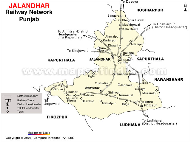
Jalandhar
Jalandhar, formerly known as Jullundhar is an ancient city in Punjab. Ruled by the Hindus and the Mughals in succession it is believed to be the oldest city in Punjab. Jalandhar today is a highly industrialized centre being India's foremost producer of world class sports equipments. The city also has the distinction of producing some of the best sportsmen in the country.
Geography of Jalandhar
Jalandhar is located on the intensively irrigated plain between the Beas and Sutlej rivers. The city, which has major road and rail connections, is a market for agricultural products. Manufactures include textiles, leather goods, wood products, and sporting goods. Jalandhar was the capital of Punjab from India's independence (1947) until Chandigarh was built in 1953.Jalandhar is situated at 710 31’ East and 300 33’ North at a distance of 146 kms from state capital Chandigarh. It is at a distance of 350 Kms from Delhi on Delhi-Amritsar Highway. It is surrounded by Ludhiana district in East, Kapurthala in West, Hosiharpur in North and Ferozepur in South. It is well connected by road and train. Nearest Airport is RajaSansi Airport, Amritsar at a distance of 90 kms.
History of Jalandhar
The city is named after Jalandhar, a demon king, who finds a mention in the Puranas and Mahabharta. According to another legend, Jalandhar was the capital of the kingdom of lav, son of Rama. According to yet another version Jalandhar is said to have derived its name from the vernacular term `Jalandhar’ means area inside the water, i.e. tract laying between the two rivers Satluj and Beas, still another name of Jalandhar had been Trigartta, as it was waters by three rivers, Satluj, Beas and Ravi.
Places of interest
Imam Nasir Mausoleum and Jamma Masjid
The 800 year old beautifully designed mausoleum of Imam Nasir is located in the heart of Jalandhar. The Jama Masjid nearby is said to be 400 years old.
Devi Talab Mandir
Devi Talab Mandir is located about one km from the railway station. The old Devi Talab has been renovated and in its centre, a new temple has been built. Recently a model of Amarnath Yatra has been built in the premises. An old temple of goddess Kali also stands by the side of the Devi Talab. The gilded Mandir is famous for the 'Hariballabh Sangeet Sammelan' held every year in December at its precincts for the past 125 years. Famous classical music exponents - both instrumental and vocal come together and perform at this gathering. In Devi Talab, there is a large masonry 200 year old tank sacred to Hindus.
Shiv Mandir
The temple situated at Gur Mandi near Imam Nasir mausoleum dates back to the Lodhi Era. Believed to be built by the Nawab of Sultanpur Lodhi, the mandir is a blend of Muslim Hindu architecture. The main gate is built in the style of a mosque while the rest of the building is in Hindu style.
Sodal Mandir
Thousands of devotees throng this temple during 'Anand Chaturdashi' in September. The child Deity here is believed to grant wishes of devotees.
Gurdwara Chhevin Padshahi
The sixth Guru of the Sikhs, Guru Hargobind visited Jalandhar during his tour of Doaba area and he was interviewed by a holy Muslim saint, Shaikh Darvesh. Gurdwara Chhevin Padshahi in Basti Shaikh, is situated at the same spot where the talk was held. The great Guru had in depth discussion with Shaikh Darvesh about spiritual matters which created good impact on the holy man. A handwritten copy of Sri Guru Granth Sahib prepared sometime between 1715 and 1728 by the great Sikh scholar and martyr Baba Deep Singh is kept here.
St Mary's Cathedral Church
St Mary's Cathedral with its rare cosmo-culture design is a tribute to the Punjabi tradition. This Cathedral at Jalandhar Cantonment, initiated by representatives of His Holiness Pope John Paul II is the only one of its kind in the East. The old church dedicated to St. Patrick was built in 1947 and the foundation stone for the new church was laid in 1986.
Tulsi Mandir
Tulsi Mandir, earlier known as Temple of Vrinda, is an ancient monument in the city located in the Kot Kishan Chand locality. It was built in honor of Vrinda, wife of the demon Jalandhara. The tank on the side of the temple is said to have been the bathing place of Jalandhara.
Desh-Bhagat Memorial Hall
Desh-Bhagat Memorial Hall has been constructed to perpetuate the memory of martyrs who has lost their lives in the fight for freedom from the British rule.
Wonder Land
Wonderland Theme Park is an amusement water park with water games and water rides. The Park spreads over 11 acres with many thrilling rides offering healthy entertainment to all age groups. The park is located about 6 kms from Jalandhar Bus terminus and 8 kms from the Railway Station on Nakodar Road. The water rides includes bumper cars, flying jets, horror house, boating, kiddies' boating, play house, flying dragon and a slide splash. The wave pool is another attraction of the water park. There is an aqua dance floor, where boys and girls enjoy dancing on the tunes of the latest Punjabi hit numbers underneath a canopy that has artificial clouds from where the water comes down like a rainfall.
359
« on: June 23, 2010, 06:27:46 AM »


Bangles or Chudi ::
(Tamil: Valayal) (Telugu: Gaaju) (Malayalam: Vala) are traditional ornaments worn by Indian women, especially Hindus. They are worn after marriage to signify matrimony. It is tradition that the bride will try to wear as many small glass bangles as possible at her wedding and the honeymoon will end when the last bangle breaks.
They are circular in shape, and, unlike bracelets, are not flexible. The word is derived from Hindi bungri (glass).[1] They are made of numerous precious as well as non-precious materials such as gold, silver, platinum, glass, wood, ferrous metals, plastic, etc.
Bangles are part of traditional Indian jewelry. They are usually worn in pairs by women, one or more on each arm. Most Indian women prefer wearing either gold or glass bangles or combination of both. Inexpensive bangles made from plastic are slowly replacing those made by glass, but the ones made of glass are still preferred at traditional occasions such as marriages and on festivals.
The designs range from simple to intricate handmade designs, often studded with precious and semi-precious stones such as diamonds, gems and pearls. Sets of expensive bangles made of gold and silver make a jingling sound. The imitation jewelry, tend to make a tinny sound when jingled.
Some men wear a single bangle on the arm or wrist called as kada or kara. In Sikhism, The father of a Sikh bride will give the groom a gold ring, a kara (steel or iron bangle), and a mohra.[1] Chooda is a kind of bangle that is worn by Punjabi women on her wedding day. It is a set of white and red bangles with stone work. According to tradition a woman is not supposed to buy the bangles she will wear.
Types of bangles ::
There are two basic types of bangles: a solid cylinder type; and a split, cylindrical spring opening/closing type. Primary distinguishing factor for these is the material that is used to make the bangles. This may vary anything from glass to jade to metal to lac and even rubber or plastic. Bangles made from gold are considered the most expensive ones.
Another factor that adds to the price of the bangles is the artifacts or the work done further on the metal. This includes embroidery or small glass pieces or paintings or even small hangings that are attached to the bangles. The rareness of a color and its unique value also increase the value. Bangles made from lac are one of the oldest ones and among the brittle category too. Lac is clay like material which in molded in hot kilns-like places to make these bangles. Among the recent entrants are the rubber bangles that are worn more like a wrist band by youngsters while the plastic ones are there to add the trendy look.
Normally, a bangle worn by people around the world is simply an inflexible piece of jewelry worn around the wrist. However, in many cultures, especially in the South Asia and in Arabian Peninsula, bangles have evolved into various types in which different ones are used at different occasions.


360
« on: June 22, 2010, 08:24:16 AM »
:scared: :scared: :scared: plzzzzzzz changeeeeeee karoooooooooo plzzzzzzzzzz :omg: :omg: :omg:
Pages: 1 ... 13 14 15 16 17 [18] 19 20 21 22 23 ... 25
|